Maximum time difference on Earth - 26 hours

Maximum time difference on Earth - 26 hours
maximum time difference


Earth's largest time difference:
Time Zone may be used to refer to the local time of a country or a region. Time zones in the world are obtained from the UTC. If each time zone were 1 hour apart, there would be 24 time zones in the world. The clocks throughout the World are not adjusted for Daylight savings as all are under the regulation of a Coordinated Universal Time (UTC). 

UTC is 0 hours which means any area on the Earth can only be ahead (+) or behind (-) the UTC. We know that there are 24 hours in a day, so we may think that the biggest time difference between two points on the earth would only be 24 hours. But, according to the standard time (UTC) which we follow, the biggest time difference is 26 hours. The reason behind this is because of the man-made imaginary International Date Line (IDL) which was agreed in 1884 at the International Meridian Conference (IMC). The IDL serves as the "line of demarcation" between two consecutive calendar dates. 


If a person crosses the IDL from the West to the East he gains a day and if he crosses from the East to the West he loses a day. If the IDL is a straight line, then the maximum time difference would only be 24 hours, but the IDL agreed is not a straight line, it is a zig-zag line. The countries which attended the IMC decided the IDL to run North pole to South pole, but make it zig-zag around political borders to avoid any confusion. Also, if it was a straight line, then it demarcates the same landmass into two parts and then both places have different dates on the same day. This is the reason the IDL is not straight in many places.
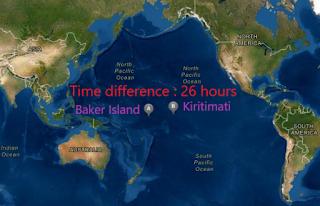
The maximum time difference between two places on the Earth is 26 hours, which is between the Republic of Kiribati’s Kiritimati (UTC + 14) and Baker Islands (UTC - 12) of the United States of America (A minor outlying island).

Both the islands are located in the Pacific Ocean in which Kiritimati falls on the Western side of the IDL and Baker Island falls on the Eastern side of the IDL. Theoretically, speaking the Baker Islands should be on the East side of Kiritimati.

But practically, the situation is different. Kiritimati lies on the Eastward side of Baker Island, but on the West of the IDL. The image on the top will give you a clear idea about how the IDL is passing between these two places and the reason for the 26 hours time difference.

Other than Kiritimati and Baker Island, the largest time difference may be accepted between Howland Island ( Another minor outlying island) of America (UTC - 12) and the Independent State of Samoa, whose Daylight Saving Time (DST) during summer is UTC + 14. Samoa uses DST to make the darkness fall later each day according to the clock. But, this may not be considered throughout the year as the DST for Samoa starts at the end of September and ends at the beginning of April.

Comments

Post a Comment

Popular posts from this blog

Korean War | change in position of the 38th parallel

Korean War history and the 38th parallel North Korea is an isolated nation that proclaims its southern neighbor South Korea as its enemy. North Korea blew up its joint liaison office with South Korea on 16 June 2020, in a dramatic and carefully planned display of rancor toward its southern neighbor. Till the end of the Second World War, there was no separate North and South Korea and they were collectively called Korea. In this article, we will see what led to the separation of Korea and the Korean War, which was fought after the separation in detail. Korean war led to the split of North and South Korea Separation of Korea At the end of the Second World War, Korea — which had formerly been occupied by the Japanese — was divided along the 38th Parallel (38 degrees North) by the United States (US) military planners Dean Rusk and Charles Bonesteel, as a temporary division of the country. But the onset of the Cold War (rivalry that developed after World War II between the US and the So...

India-China : No military weapon used at border since 1975

Despite ceasefires, no weapons have been used at the disputed Sino-Indian border China has built new structures near the border. Recent images from June 22 show China has built new structures near the location of a Himalayan border. New Chinese bunkers, tents, and storage units that weren't previously there in earlier within the month. A fatal clash at the India-China border in the Ladakh area has claimed the lives of 20 Indian and 43 Chinese soldiers on 15 June 2020. Foreign ministers of both the countries have held telephone talks over the deadly border clash, agreeing to "cool down" the tensions. India accuses the "violent face-off" is an attempt by China to "unilaterally change the status quo" on the Galwan Valley frontier in Indian administered Ladakh. China, in turn, accuses the Indian army of "provoking and attacking Chinese personnel, resulting in serious physical confrontation". In this article, we will know the reason for the disuse...

Penguins contribute to Climate Change

Penguins contribute to climate change The Earth’s average temperature has been keeping on increasing at a rapid pace over the past few decades. A major problem that contributes to the increase in global temperature is the presence of greenhouse gases in the atmosphere. When the Sun’s energy reaches the Earth’s atmosphere, some of it is reflected into space and the rest is absorbed and re-radiated by the greenhouse gases. The absorbed energy warms the atmosphere and therefore the surface of the world. This process maintains the Earth’s temperature at around 33 degrees Celsius warmer than it might rather be, allowing life on Earth to exist. Climate forcing is the change in the balance between radiation coming into the atmosphere and radiation going out. A positive radiative forcing tends on the average to warm the surface of the world, and negative forcing tends on the average to chill the surface. Likely, human activities such as burning fossil fuels, agriculture, and land clearing are ...